+91-8929175340
2 Nights / 3 Days
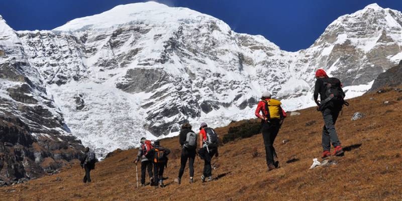
Bhutan’s trekking season primarily falls in spring and autumn, with limited options available during winter. However, despite the cold, winter often brings clear skies, offering spectacular mountain views. This three-day trek is a fantastic way to experience winter trekking while also enjoying cultural highlights. Starting from the northern reaches of Thimphu Valley, the route crosses Sinchula Pass (3,315m), a natural divide between Thimphu and Punakha, leading to a stunning alpine lake before concluding in the picturesque countryside of Punakha.
Trip Facts
Duration: 2 Nights/3 Days
Best Time: Jan -May & Sept-Dec
Highest Altitude: 3,315 m
Difficulty Level: Easy - Medium
Longest Walking dist:11 km
Longest Walking Time: 6 hrs
11KM | 6-7 HOURS | ASCENT 650M | DESCENT 995M | CAMP ALT 2320M
Drive 12 km north of Thimphu Valley, passing through the small town of Dechencholing before taking a left turn through the expansive village of Kabisa. Following the road along the right side of the village, you’ll journey through a forest of pine trees, with glimpses of the serene countryside, until you arrive at Chambina (2,665m)—a small meadow near the Chambina River. Here, your trekking crew will be waiting to greet you.
After loading your baggage onto pack horses, the trek begins. The first ten minutes are an easy, gradual walk along a rough motor road before the trail takes a left turn, ascending for about an hour to reach Barnakepa (3,135m), a vast meadow surrounded by pines, spruce, oak, and scattered maple trees. Along the way, you may spot yellow-billed blue magpies and common nutcrackers flitting through the forest.
Continuing the trek for another hour, you will reach Sinchula Pass (3,315m), marked by an ancient Bhutanese chorten and fluttering prayer flags. Take a well-deserved break here and soak in the views. To the right of the pass, an off-road mountain biking trail leads to Dochula, but instead, we take the left path, descending towards Chulujangsa (2,830m), our designated lunch spot.
After lunch, the descent continues for another hour, revealing breathtaking views of the villages of Upper Begana and Thinleygang in the valley below.
Walking further down we reach at the campsite Dushipang at 2320m.
2050m12KM | 6-7 HOURS | DESCENT 270M
After breakfast, we descend through lush subtropical forests filled with wild ferns, scattered bamboo groves, and Daphne plants. Along the trail, wild nuts and fruits can be found—when we first did this trek in late November, they were in abundance.
After more than an hour of trekking downhill, we reach a suspension bridge known locally as Gedhothusazam. According to legend, the local deity Ap Gaynen gathered stones from this area, giving the bridge its name.Crossing the bridge, we arrive at a road junction and take the left path. A 20-minute walk brings us to the picturesque village of Tongzhingnang. Continuing on, we pass a few traditional farmhouses before making a short descent, followed by a gradual uphill walk along a stream. This leads us to a cow herder’s camp, an ideal spot for lunch.
After a break, we continue trekking uphill through a dense forest with moss-covered undergrowth, wild ferns, betel leaves, and stinging nettles. A steep ascent brings us to a small saddle-like pass, marked by a hidden stone chorten nestled among the bushes and trees. From here, we descend via a series of switchbacks, eventually reaching a three-way junction. Taking the middle path, we arrive at an elongated meadow called Margay (2,070m) and, finally, at Kabjihoka Tsho Lake (2,050m), our campsite for the night.
The lake is teeming with fish and surrounded by diverse bird species. Local folklore tells of a fascinating legend: it is said that a water buffalo once belonging to the lake deity resided in the waters but was killed by the people of Kabisa, a village below. When the villagers attempted to cook the meat, no fire could make it tender. As a result, a curse was placed upon Kabisa—no matter how hard its people work, they will never achieve wealth like the neighboring valleys.
11KM | 4-5 HOURS | DESCENT 340M
Before breakfast, take some time to soak in the serene beauty of the lake and its panoramic surroundings. Then, retrace your steps for about 30 minutes back to Margay before following the right trail down to a vast, swampy meadow called Tabatsa. Another trail to the right leads to Rowu Tsho, a lake named for its horn-like shape. However, since horses cannot cross the swampy terrain, we take a side trail to the right instead.
After a short ascent, we begin a descent through warm subtropical forests toward Kabisa Village. The trail is lined with wild orchids, blooming flowers, and fruit-bearing trees, making for a scenic and refreshing walk. After crossing a small stream, we follow an irrigation channel until we meet the farm road. Walking along the road through Kabisa Village, we arrive at Chorten Ningpo, a historic monastery home to around 40 monks. In front of the monastery stands an ancient oak tree, steeped in legend. According to local lore, the tree grew from a burnt twig thrown from Jilligang hilltop by the Divine Madman, Drukpa Kunley, in an effort to subdue a gathering of evil spirits at the site.
From the monastery, enjoy sweeping views of the surrounding villages before concluding your trek. A scenic 20-minute drive through rural landscapes takes you to Punakha Valley, where you will spend the night at a hotel.
We deal in Tour Operator Services. Read More...

 12D/11N
 8D/7N
8D/7N
8 Days Beautiful Bhutan Tour With Bumdra..
Paro - Wangdue Phodrang - Thimphu - Punakha
 9D/8N
9D/8N
9 Days Western Bhutan Walking Holiday Tour
Paro - Punakha - Thimphu - Wangdue Phodrang
 11D/10N
11 Days Luminous Bhutan Photography Tour
Thimphu - Paro - Punakha - Wangdue Phodrang
 9D/8N
9D/8N
 8D/7N
8D/7N
7N - 8D Bhutan Buddhist Pilgrimage Tour
Thimphu - Paro - Punakha - Wangdue Phodrang
 10D/9N
Honeymoon In Beautiful Bhutan 9N - 10D T..
Thimphu - Paro - Wangdue Phodrang - Punakha - Bumthang
 13D/12N
 11D/10N
 3D/2N
3D/2N
 3D/2N
3D/2N
Srinagar ,Pahalgam , Gulmarg, Sonamarg, ..
Srinagar - Pahalgam - Gulmarg - Sonamarg
 3D/2N
3D/2N
 3D/2N
3D/2N
 3D/2N
3D/2N
 3D/2N
3D/2N
 3D/2N
3D/2N
 3D/2N
3D/2N
 3D/2N
3D/2N
 5D/4N
5D/4N
 7D/6N
7D/6N
6 Nights/ 7 Days - Bhutan Happiness Tour
Punakha - Bumthang - Paro - Thimphu - Phobjik
 7D/6N
7D/6N
 7D/6N
7D/6N
 20D/19N
20 Days Land Package Country Tour Bhutan..
Punakha - Paro - Phuntsholing - Bagdogra - Bumthang - Mongar - Trashigang - Trongsa..
 4D/3N
4D/3N
 6D/5N
6D/5N
 7D/6N
7D/6N
 7D/6N
7D/6N
Rimso 7 Days 6 Nights Bountiful Tour fo..
Thimphu - Punakha - Paro - Phuentsholing