5 Nights / 6 Days
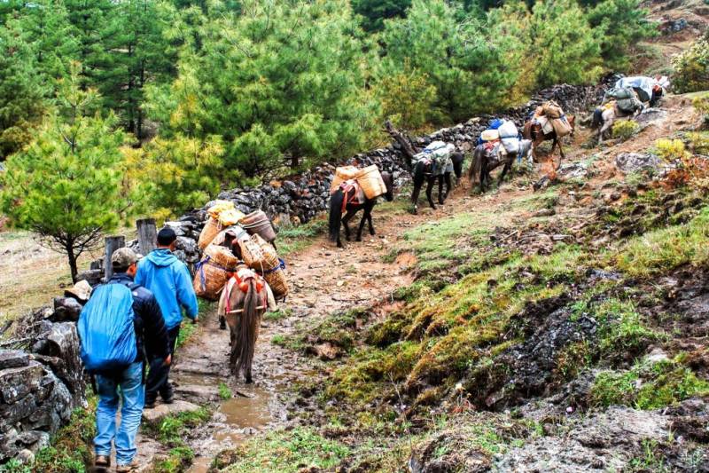
The Sagala Trek route is also called the ‘Haap’s(people of Haa) Trail’ as in the ancient times, this was the trail that the people of Haa takes to Paro to take part in rice cultivation and harvest. Haa valley is not much visited by tourists, and particularly Sagala trek is a beautiful 3 days hike through beautiful meadows along the high ridge across virgin forests rich in flora and fauna. The panoramic picturesque view of the Paro valley and Haa Valley on either side as you walk along the sky line ridge is wonderful. One of the main highlights of this trek is the absolute gorgeous view of Mount Jhomolhari in Bhutan and Kanchenjunga and Mount Everest of Nepal.
Trip Facts
Duration: 9 Days
Best season: April, May, Sep, Oct & November
Group Size: 2 & above
Trek grade: Medium
Accommodation: Hotels/Camping
Avg. Walking Dist.: 9Km
Avg. Walking Time: 5 Hours
Max. Elevation: 4350m
Highlights
Trek to the holiest temple of the country, Taksang Lhakhang (Tiger’s Nest).
Trekking into popular Sagala Nature trail of Haa and marveling the stunning views of the mountains and valleys as one treks along the high mountain ridge.
Discovering and learning about sky burial site and tradition in Bhutan.
Discovering and Witnessing life in isolation, far into the mountains by Monks and Nuns at Chela Nunnery.
Tour the landmarks in Paro, Thimphu and Punakha.
Paro Elevation: 2360m
Fly into Paro with Drukair or Bhutan Airlines. The flight provides during a clear weather the most fascinating view of Himalayan scenery. As the aircraft enters the Paro valley you will see the Paro Dzong overlooking Paro Chu with Ta Dzong above it. Your guide will receive you at Paro Airport and escort you to hotel. Later in the evening, you can visit Paro town. Overnight hotel in Paro.
Distance: 6.4 km (Round trip)
Time: 3 to 4 hours
Asscent: 900m
Descent: 900m
Taktsang Alt:3100m,
Chelela Alt: 3889m
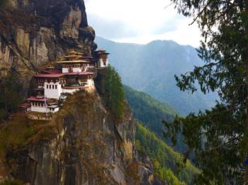
Right after breakfast drive towards the road point to Taktshang. Taktshang Monastery stands at 900m above the Paro valley floor and it was wonderfully built on the face of a high cliff. As you look upon the monastery from down below it appears impossible to reach. At a normal pace it can take about 2 hours but you will find it’s a life time journey all the way up to the monastery and then inside the monastery which you will find yourself into taking more times. Taktshang means “Tiger’s Nest,” so named when Guru Rimpoche flew to the site of the monastery on the back of a flying tigres in 8th century. This day hike is not only historically and culturally interesting, but also incredibly scenic.
Afternoon drive to Haa via Chelela Pass (3980m) which is the highest road pass in Bhutan. In the evening you start sorting and packing your trekking equipment for the next day. You can pack those things that you don’t need on the trek separately and keep them with your driver. Overnight stays at the hotel in Haa.
Distance: 6 km
Time: 3 hours
Ascent: 450m
Camp Alt: 3150m
Your trek begins in the Haa Valley (2670m) through an unpaved motor road for less than an hour passing farmland and farm houses. Once you leave the settlements you enter vast pastures lands, meadows and alpine forest. The trail gradually climbs up and arrives at a junction point where the left one goes to the summer yak herding camp and further to the border of Tibet. We keep on the right trail towards our camp at Sagala (3150m).
Distance: 9km
Time: 6 hours
Ascent: 700m
Descent: 250m
Camp Alt: 3850m
Begin climbing up for 30 minutes to Sagala pass, on clear weather, you will have superb views of Mount Jumolhari (7314m) and Jichu Drake (6989m). From the pass, walk on the right side along the ridge through thick Juniper forest. Switching between small ascents and descents the trail gradually ascends to the top of the ridge at 4435m. From here the trail gets level and walking gets more easy passing through rhododendrons and Juniper often coming out into open meadows with great views of Haa Valley below. Through the spring and summer season the whole mountain side is covered with varieties of flowers and you cannot help shooting for photos. Towards the far end of the mountain slope the trail gently descends to the Nyingula camp at 3850m.
Distance: 11km
Time: 6 hours
Ascent: 500M
Descent:360m
After Descending from the camp for few minutes and following the ridge through meadows and yak herder’s camp, we enter into thick woods of alpine forest finally coming out into a vast open mountain slope. The uphill climb begins from here until we reach Gung Karpo, Sky Burial site at 4350m. As you walk along the ridge the view on both sides gets superb. After relaxating on the top for some time you will descent amidst huge grassy mountain slope then into rhododendron woods and suddenly you will find yourself at the vicinity of Kila Goenpa Nunnery, a place of utter silence and tranquility built far in the mountains and standing against a cliff face. After visiting this special place you will walk down to the road head and drive to Paro where hot shower awaits you at the hotel.
Your guide and driver will drive to you to Paro airport for your onward departure.
We deal in Tour Operator Services. Read More...

 12D/11N
 28D/27N
 11D/10N
 16D/15N
 9D/8N
9D/8N
 3D/2N
3D/2N
 10D/9N
 10D/9N
 6D/5N
6D/5N
 6D/5N
6D/5N
Chardham Yatra By Helicopter Tour
Yamunotri - Gangotri - Kedarnath - Badrinath
 6D/5N
6D/5N
Srinagar,Pahalgam,Gulmarg,Sonamarg,Srina..
Srinagar - Pahalgam - Gulmarg - Sonamarg
 6D/5N
6D/5N
 6D/5N
6D/5N
 6D/5N
6D/5N
 6D/5N
6D/5N
 6D/5N
6D/5N
 6D/5N
6D/5N
 5D/4N
5D/4N
 7D/6N
7D/6N
6 Nights/ 7 Days - Bhutan Happiness Tour
Punakha - Bumthang - Paro - Thimphu - Phobjik
 20D/19N
20 Days Land Package Country Tour BHUTAN..
Punakha - Paro - Phuntsholing - Bagdogra - Bumthang - Mongar - Trashigang - Trongsa..
 4D/3N
4D/3N
 6D/5N
6D/5N
 7D/6N
7D/6N
 7D/6N
7D/6N
Rimso 7 Days 6 Nights Bountiful Tour fo..
Thimphu - Punakha - Paro - Phuentsholing
 7D/6N
7D/6N
 8D/7N
8D/7N
Jalpaiguri - Thimphu - Paro - Punakha - Phuentsholing