22 Nights / 23 Days
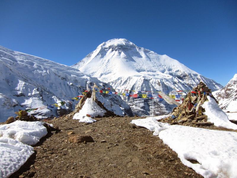
The Dhaulagiri Round Trekking is a rough and classic adventure journey in the Himalayan region of Annapurna and is quite the trek. A challenging and thrilling adventure trek perfect for those seeking an adventure and a rough holiday in the high mountain areas, Dhaulagiri round trekking is a teahouse and a camping trek. Still a remote and a rugged region that has comparatively fewer trekkers even in the high season, this trek will be a perfect choice for those brave ones who wish to take risks and trek in the remote and isolated region.
A morning flight to Pokhara is from where the Dhaulagiri Round Trek begins and we stay the night at a cozy hotel. A drive to Darbang starts the trek (we'll fly back at the end from Jomsom). We walk to the south of the Dhaulagiri Massif, first along the Kali Gandaki and later, through the Myagdi Khola valley, on the first three days of the trek. Through the trek, we go through various climates and temperatures can be reasonably warm walking through the terrace farming lands. From Muri, we follow the trail north, in the direction of the Dhaulagiri Massif, to Dhorpatan. With its seven summits above 7,000m, the Dhaulagiri Massif with its bouquet of mountains is undoubtedly one of the most impressive mountain peaks in the world. The trek takes us through increasingly difficult paths high above the Myagdi Khola River. As the terrain becomes steeper, the trekking days become necessarily shorter, in order to acclimatize to the high altitude. We also encounter a marvelous U-shaped glacier valley to reach the Chhonbardan Glacier, and eventually Dhaulagiri Base Camp at an altitude of 4,750 m.
During the Dhaulagiri Round Trek, it is mandatory, we stay at the base camp for one day to acclimatize and to breathe in the fabulous views of the surrounding mountains. Speaking of the toughest day of the trek, it is when we cross the French Col (5,350 m) to reach our highest camp site is in the Hidden Valley, located at 5,000m. If we are lucky enough to have clear weather conditions, this section of the trek is not too difficult, but the Hidden Valley and the Dhampus Pass should definitely not be underestimated and are notorious for attracting bad weather. At the Dhampus pass, we hope to enjoy breathtaking and marvelous views of Tukuche Peak, Dhaulagiri (8,167m), Nilgiri and the Annapurna Massif. For those daredevils who have opted to try and climb the Dhampus Peak, the potential reward is a 6,000m snow summit with a breathtaking view. After the difficult descent down the north side of Dhampus Pass, we finally reach Marpha, the apple wine town which is on the Muktinath trekking route. When we get to Jomsom, we fly back to Kathmandu via Pokhara.Sightseeing or any extra activities except the above program
Personal nature expenses
Bar bill and all kind of drinks
Rescue & Evacuation
Gratitude (tip) for staff
Upon arrival at Kathmandu airport, meet one of our trek leaders and transfer to hotel. In the evening join the welcome dinner at a typical Nepali restaurant, enjoy the local meal with a short brief about your trek. Overnight at hotel.
Breakfast will be at hotel, today is rest and trek preparation day. Upon your request, we can organize a sightseeing tour of Kathmandu valley. In the evening, there will be trip briefing and we will introduce you to guide and trekking crew. Overnight at hotel.
This demanding adventure trip begins with a flight from Kathmandu Pokhara, where we overnight in a nice lodge. From here we drive to Darbang via Beni. We will fly back from Jomsom at the end of the trek. The road from Pokhara is a rough track and from Beni to Darbang is little more than a scar scratched through the valley, which barely permits the passage of motor vehicles. However, the driving it is less unpleasant than walking amongst the traffic and dust and saves a day and a half walking. We camp at Darbang at an altitude of 1,180m.
This demanding adventure trip begins with a flight from Kathmandu Pokhara, where we overnight in a nice lodge. From here we drive to Darbang via Beni. We will fly back from Jomsom at the end of the trek. The road from Pokhara is a rough track and from Beni to Darbang is little more than a scar scratched through the valley, which barely permits the passage of motor vehicles. However, the driving it is less unpleasant than walking amongst the traffic and dust and saves a day and a half walking. We camp at Darbang at an altitude of 1,180m.
Morning we cross the suspension bridge over the Myagdi Khola (khola = river), the main valley that we will be following towards Dhaulagiri. We leave the world of motor vehicles for the next about 2 weeks. The trail initially follows the West side of the river, before crossing a small bridge over the Dang Khola at Phedi, then climbing steeply up a zig zag path on a spur to reach the village of Dharapani. The trail contours through cultivated and populated hillsides, with a lunch break possibly in Sibang, before we choose our campsite at Phallya Gaon for the night at around 1,800m.
We leave Phallya Gaon by crossing a small suspension bridge over the Dara Khola, climbing the other side of the Khola, then traversing round to the village of Muri. The path is the main route through this valley so has a lot of local traffic - folk going about their daily business, cattle and horses, and other trekking groups. The backdrop is the panorama of this part of the Himalaya. To the North West we can see Gurja Himal (7,193m), Konabon (6,570m) and Myagumath (6,273m). To the north east, Dhaulagiri 1 (8,167m) and Manapati (6,380m). Muri is in a large, terraced bowl in the hillside and from here we descend several hundred meters to cross the Muri Khola by a new metal bridge, then climb over a steep, forested ridge to descend the other side to find ourselves once again on the west bank of the Myagdi Khola. With a lunch stop in the forest somewhere along the way, we camp for the night at Jugapani at around 2,000m. This is near where the trail is joined by the track from the east side of the Myagdi Khola from Darbang. Overnight at camp.
Fairly soon after starting out this morning, the trail climbs steeply before contouring a steep slope high above the river. After a while there is a fork in the path - the original path which climbs even higher to avoid a barrier of cliffs - or the lower route which most parties seem to opt for (it is a good 2 hours shorter but it involves a couple of hundred meters of very steep, narrow and exposed path which is safeguarded by "in situ" rope hand rails). Porters with baskets need additional safety ropes, and it may be prudent to back up the existing ropes with additional ones for the safety of the whole party. This section of path was started about 6 years ago, but funds ran out, and there is a section of only 10 meters or so that still need a path carved into the cliff face, hence the exposed detour. After this however there is a straightforward final steep climb to gain the huge, cultivated bowl that is Boghara at around 2,080m. From Boghara the path goes up and down, wet at times, staying on the west bank of the Myagdi Khola, taking us through fantastic Himalayan forest, with the possibility of seeing monkeys playing in the trees. A beautiful walk, with one more short, steep section which has been constructed across another cliff. We have lunch somewhere along the way, ending today at Dobang (2,260m). Dobang is a clearing in the forest with a tea house and space to camp near the base of the Konabain Khola, under the east face of Dhaulagiri 4.
Today's walk continues through the forest, a bit like a gigantic natural Botanical Gardens Walk! First we cross the Konabain Khola, and then cross the Myagdi Khola, both on seasonal wooden bridges (interesting!).The path then stays on the east bank of the main valley, reaching Soligari at 3,100m after a few hours. Overnight at camp.
It is useful to have a rest day after the first few days of trekking, though if everyone is acclimatizing well and feeling good, we may opt to save this day for use later on in the trip, in the event of bad weather.
From Soligari we cross the Choriban Khola flowing down from the east. The valley suddenly opens up and we begin to see the huge west face of Dhaulagiri 1 and the peaks towering above the west side of the Myagdi Khola. The forest becomes less dense, with more bamboo and eventually after climbing a steep ridge, we come out of the forest altogether and onto the open hillside under the west face of Dhaulagiri 1. This has become known as the Italian Base Camp and will be home for two nights at an altitude of 3,600m.
A rest and acclimatization day to give us a chance to catch up with domestic chores and writing up log books. It's not a bad idea to do a little 'active pottering', exploring the area and living in awe of something like 4,500 meters of mountain overhead!
To gain access to the upper valley, that will in turn take us to the Chhonbardan Glacier, we have to cross a huge breach in the moraine and the frozen debris of a massive avalanche fan that forms at the bottom of the west face. The initial descent down the moraine slope is very step, so the Sherpas will run a rope out as a hand rail, as much for the benefit of the porters as for the group. Climbing the slopes on the other side is straightforward (if steep); this section could present problems if icy, or if covered in fresh snow. Once in the upper valley, we pass the site of a large bivouac cave, and the sites of the American and French Base Camps. The path is now back on the west side of the river, and soon leads us onto the Chhonbardan Glacier, which is completely moraine-covered in its lower reaches. At around 4,220m there are platforms leveled on the glacier's surface, which can accommodate our camp for the night. This is quite a short day, but it is important not to ascend at this altitude too quickly.
Another fairly short day, taking perhaps 4 or 5 hours to walk up the moraine-covered Chhonbardan Glacier to "Dhaulagiri Base Camp" at 4,600m. Base Camp is really a huge area of the glacier where expeditions have based themselves over the years. Terraces have been leveled on the stony ground and there is a choice of sites depending on who else is around. As at Italian Base Camp, we will spend 2 nights here to become well acclimatized before going over 5,000m.
Another day for domestics, exploring, and taking in the magnificent setting. To the east is Tukuche Peak (6,920m) and to the south, we can look onto the north side of Dhaulagiri 1.
The path from Base Camp goes along the north side of the glacier. It is flat for a while, and then it climbs a steep bank to eventually follow the crest of a massive moraine ridge to wide, open slopes that lead to the crest of French Col/Pass at 5,400m. It should take 4 or 5 hours to get there. Cairns, prayer flags and wonderful views provide distraction for a rest before descending easy slopes into "Hidden Valley", where we find a campsite for the night at around 5,050m.
A pre-dawn start is the order for our ascent of Dhampus Peak. A straightforward climb technically, the terrain is likely to be a mixture of frozen snow fields, and patches of slatey scree. At approximately 1,000m of ascent from high camp to the summit, you can expect this to be a very tough day physically. Breaking trail after fresh snowfall would make it an even more arduous climb. There is a long ridge of a mixture of very shattered slatey rock and snow, with occasional steps to negotiate. Axes, crampons, harnesses and ropes need to be carried, but may not be needed depending on the circumstances of the day. Cold is more likely to be a bigger issue, and it is essential that everyone is prepared for potentially very low temperatures, and a high wind-chill factor. The summit, at 6,060m is a fine rocky peak with extensive views of the Annapurnas to the south east, the Dhaulagiris to the south west, and Mustang to the north. The descent involves going back along the ridge a short way before descending slopes heading south for about 1,000m to join the path that crosses Dhampus Pass from Hidden Valley. We will be met here by those choosing not to climb and the cook team, who will be waiting with refreshments.
We include a spare day in the itinerary to allow for the flexibility that is mandatory on a trek such as this. All the factors that contribute to the outcome of such an itinerary need to come together, and any of weather, conditions underfoot, health, acclimatization, logistics can easily disrupt the best laid plans.
From our camp somewhere below Dhampus Pass, we continue along to the west edge of the Kali Gandaki Valley, where we descend to Yak Kharka for the night, at 3,680m. It would be a huge descends all the way from Dhampus Peak into the bottom of the valley, so we need to split this in order to save our knees!
From Yak Kharka it is still over 1,000 meters to the floor of the valley, but once there, it is only about an hour's walk north east to Jomsom. We will stay here for the rest of the day and overnight in anticipation of our flight to Pokhara tomorrow. In the event of bad weather and there being no flights out of Jomsom, the alternative is to walk, jeep and bus south to Beni. This valley is part of the famous Annapurna Circuit, but a road has been extended to Jomsom, so it is now possible (if uncomfortable) to travel by motor vehicle.
After breakfast, we fly out from Jomsom to Pokhara, this is about 25 minutes flight over the Annapurna massifs. Upon arrival at Pokhara, we check in to a comfortable hotel. In the evening, stroll around Lakeside and enjoy the evening meal at bank of the Phewa Lake. Overnight at hotel.
After breakfast at hotel, we will take a tourist bus ride to Kathmandu or enjoy Pokhara till midday and take a 25 minute flight back to Kathmandu. Overnight at hotel.
For those eager to see as much of Kathmandu as possible, an early start is worthwhile to visit the temples of Pashupatinath and Swayambhunath and districts of Bhaktapur and Patan. Durbar Square is also on the essential list, as is the shopping area of Thamel. Evening we provide you farewell dinner at typical Nepali restaurant to celebrate your great trip.
After breakfast, we will drop you to international airport for your flight back to home. We wish you have a safe and sound flight back home. Hope to see you again in the future.
We are Dealing in Tour & Travels Services. Read More...
 10D/9N
 17D/16N
Annapurna Circuit Trekking Package
Kathmandu - Jomsom - Dalhousie - Besi Sahar - Khudi - Bahundanda - Chamje - Pisang ..
 21D/20N
Annapurna Khayer Trekking Pacakge
Kathmandu - Pokhara - Ghorepani - Kota Kinabalu - Dhampus - Tolkha - Jhinu Danda - ..
 18D/17N
Kathmandu - Beni - Bhabichaur - Dharapani - Lamsung - Gurjaghat - Rupachaur - Lamsu..
 9D/8N
9D/8N
 21D/20N
 15D/14N
Kathmandu - Pokhara - Ghorepani - Hyderabad - Nayapul - Nayapul - Ulleri - Tatopani..
 13D/12N
Annapurna Sunrise View Trek Package
Kathmandu - Pokhara - Ghorepani - Dhampus - Landruk - Tadapani - Poon Hill - Tikhed..
 11D/10N
Panchase Hill Trekking Package
Kathmandu - Pokhara - Kota Kinabalu - Khade khola - Bhumdhi - Panchase bhanjang - B..
 23D/22N
New Delhi - Jaipur - Nawalgarh - Mandawa - Bikaner - Jaisalmer - Osian - Khimsar - ..
 23D/22N
New Delhi - Amritsar - Dharamshala - Patnitop - Srinagar - Kargil - Leh Ladakh - Ma..
 23D/22N
 23D/22N
 23D/22N
 23D/22N
 23D/22N
 23D/22N
The Rural Tours of Rajasthan India
New Delhi - Samode - Nawalgarh - Khimsar - Jaisalmer - Jodhpur - Sirohi - Ranakpur ..
 23D/22N
New Delhi - Manali - Kullu - Amritsar - Mcleodganj
 12D/11N
11 Nights - 12 Days Nepal Tour From Gora..
Prayagraj - Gorakhpur - Varanasi - Ayodhya - Kathmandu - Pokhara - Chitwan - janakpur
 12D/11N
11 Nights - 12 Days Nepal Tour From Gora..
Prayagraj - Gorakhpur - Varanasi - Ayodhya - Kathmandu - Pokhara - Chitwan - janakpur
 12D/11N
11 Nights - 12 Days Nepal Tour Package - 2
Prayagraj - Gorakhpur - Varanasi - Ayodhya - Kathmandu - Pokhara - Chitwan - janakpur
 12D/11N
Prayagraj - Varanasi - Bodhgaya - Ayodhya - Pokhara - Chitwan - Parsa
 8D/7N
8D/7N
8D Kathmandu - Chitwan - Pokhara - Lumbi..
Kathmandu - Pokhara - Lumbini - Chitwan - janakpur
 3D/2N
3D/2N
 6D/5N
6D/5N
 18D/17N
Best of North & West India with Nepal Tour
Mumbai - Kathmandu - New Delhi - Jaipur - Fatehpur Sikri - Agra - Jhansi - Varanasi..