4 Nights / 5 Days
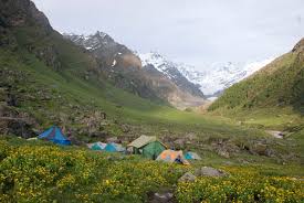
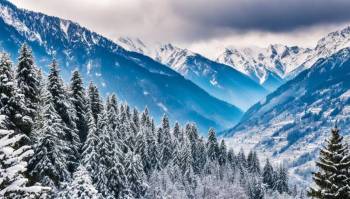
Himachal Pradesh is one of the most toured states in India. The state has beautiful pristine snow clad mountains which are a major source of tourist attraction. Tourists from all over the world come to this glorious, unpolluted and serene place to nurture their mind and soul and cherish an unfathomable nature's beauty. The word 'Hima' means snow in Sanskrit and hence the name Himachal Pradesh which means 'In the lap of Himalayas'. The mountains of the state are used for many adventure sports. One among them that is considerably being carried out here is trekking.
With more than 200 defined trekking trails some of the famous trekking spots of Himachal Mountains are; Hampta Pass trek, Dhaulandhar (Triund Glacier)trek, Parvati valley trek, Bhabha pass trek, Sari Pass trek, Beas Kund trek, trek to Chamba and Pin Parvati, Kakeri lake trek etc.
Hampta pass trek is considered the easiest and convenient of all treks in H.P. It might not be the most adrenalin rush giving or the most sought after trek, but definitely it is a trek that will leave you in awe of this beautiful place. The variation in the trails is enormous; scenic landscapes, open green pastures and meadows, glacial valleys, easy access and an exceptional, adventurous and hair raising crossing of the pass makes this trekking expedition to Hampta pass an exciting one.Generally, it takes 4 days to complete the Hampta pass trek, but one more day is further added to the itinerary so as to visit the well-known and striking Chandrataal, a high altitude alpine lake few hours from Chatru. The best months to trek are May and June and August through October. The reason why Hampta pass is famous trekking zone is snow; the pass has lump sum snow which draws more tourists.
The nearest station is Manali. Therefore, the trip starts from Manali to Chika via Jobra. From Jobra the trek is undertaken by walk. This route comprises the first day. Balu ka Ghera is reached on the second day. You would cross amazing boulders, Gendrame and Rani Nallah on this day. The third day destination is Shea Goru from Balu ka Ghera via Hampta Pass. You will come across mind boggling and stupendous glaciers, cornice formation and snows all the way along. The maximum altitude will be reached on this day i.e. 14, 100 ft. Day four will start from Shea Goru and end up in Chatru. It is a steady descent on this day. You will witness the valleys of Lahual and Spiti and also the mountain ranges of Pir panjal and Spiti. On the same day you can also head to Chandra tal camp site and camp there for the night. The final day of the trek's route is from Chandra tal to Manali. From Chandra tal campsite you can visit the infamous chandratal lake, deepest amongst blue shades.
One must carry necessary trekking gears like ankle support shoes and trekking poles which will make snow climbing easier.
The trekking jaunt begins from Manali to Jobra in vehicle. Manali is already at an elevation of 6,700 ft above sea level. So, it is a fantastic destination to acclimatize your body before commencing the trek. It is a two-hour and forty minute ride to Jobra. Jobra is perched at an altitude of 9,800 ft. On the first day you will reach a loftiness of 10,100 ft and cover up two to three hours of trek. The trek on foot begins from Allain Guhugal Hydel Project junction. After crossing the main road, take the small path that ushers to the forest of pine trees. You will also spot other ranges of trees like maple, deodar, toss and oak. The view is refreshing. The slant that is supposed to be climbed is an easy one and not very steep. Twenty minutes into the trek, you will reach a bend that overlooks a verdant green meadow tossed with small rocks. Enjoy the milieu for a couple of minutes and head towards the meadow. The Rani nallah comes into sight which flows directly in the middle of the meadow. You will also sight herds of sheep and cows grazing in the field. The sight looks exactly as if taken out from a fable. You can pass through the meadow or climb up the hill on the left hand side. Either way you will reach Chika which is at the end of the vast meadow. But, climbing the hill and descending down to Chika is a simplified and easier route. Chika camp site is a huge, commodious expanse of green. The Rani River trickles in the middle makes this place idyllic for setting up the tents. Altitude:- Jobra 9,800ft to Chika 10,100ft 2 hour drive to Jobra from Manali 2km, 45 minutes trek from Jobra to Chika Enough water through the trail Easy to Moderate trail Stay at tent Meeting time at Manali is 12 pm to reach Chika camp site by 5 pm
The subsequent destination is Balu ka Ghera which is non-observable from the Chika campground. But you can make an idea as it falls to the right. Chase the left bank of the river that will come into sight at your right hand side. The passage leads to a slope of boulders and jagged terrain. The path is effortless and can be accomplished without any trouble. You will find an entire stretch of the river's right bank queued with exquisite dwarf Rhododendron trees. These trees will cover the lower and the central area and assortment of silver birch trees cover up the upper section. Once you have reached the end of silver birch trees, wait a moment and look back to awe-inspiring range of Dhauladhar snow-ridden peaks in front of you. The view is very picturesque. You will reach a pristine stream waterfall to the left at a distant. Best place to fill in your bottles. After crossing the waterfall, the subsequent route is towards the river to your left. You can go to the other side only by crossing the stream by wetting your feet. The water is bone-chilling and will surely prick your feet. You can also jump from one rock to another in the stream and get to the opposite side. You must have finished half of the day's hike when you enter Jwara. Jwara is a tantalizing sheltered valley; huge snow-decked rocks at one side and the valley drops down to the river on the other side. You will feel like immersing yourself in the charm of God's nature. You will find snows soften into the river and cattle grazing the land. In front of the scenery is snow-clad mountains, and at the rear lies, the Hampta Pass. From here, the trail would be by the river side which will show the way you to another rectangular valley. The path is covered with multi-hued flowers. The last of the tree lines disappears out of the sight and is left behind. It will take another half an hour or so to reach the end of the valley, which is the finishing part of Jwara. After Jwara, the path is a slope shrouded under snows and rocks. The closing of the path is Balu ka Ghera, the name has nothing to do with the place. The place is adorned with snow and greens whereas the name translates to mound of sand. But it is said that this place was formed with the sands and dust deposited by the river. Balu ka Ghera campground is a flat ground amidst the mountains that you will cross the next day to reach the pass. Balu ka Ghera is set at an altitude of 11, 900 ft. Chika to Balu ka Ghera Altitude:- 10,100ft to 11,900ft 8.5Km, 6hr trek Moderate trail, gradual ascent Pack lunch will be provided Enough water on the way River crossing, boulder walk and colourful tiny flowers on the way Enjoy the camp site.
The trek for the day encompasses 19 hours. You can bifurcate the journey in two halves, a steady rise on moderate steep slope to Hampta Pass, thence a sharp descent to Sia Goru. The loftiest elevation will be achieved on this day at Hampta Pass (14, 100 ft). The day starts by ensuing towards the mountains you spotted the preceding day. The trail is set along the river side. The view is marvelous, tiny yellow and orange flowers give pleasing scenery to the river. The river side trails leads you further to the base and then the actual climb to the Hampta pass takes place. It will take an hour to reach here. Another hour of stroll will lead you to the first plateau. In summer, the place is entirely covered under the shimmering snow. Otherwise, it is just patches of snow everywhere. The Deo Tibet peak will stand right in front of you. You will reach another plateau and then to a crest. It will take another thirty minutes to reach the ridge's end. Then from the first ridge, trek further up to get on the second ridge. Hampta Pass is just a couple of meters and a bend away from the second ridge. The climb to Hampta Pass is a vertical one and is a catch 22. It will take about 15 minutes to reach the pass. Yes, by the time you reach there, you would be dog-tired but the site which enfolds in front of you is spectacular. Relish the dazzling sight for sometime in the pass, savor your lunch, and then get ready for the subsequent descent to Siagoru. The slump is trickier than the journey to the pass. The downhill is so steep that you would not be able to spot the base of the mountain, not even by craning your neck. The best likely way to get down is either by sliding down the slope or with the use of ropes for hold up. The pathway is a little meandering too. You will also get a glimpse of Spiti from this point. In an hour and a half, you will reach the base of the valley that will lead you to Siagoru. The valley is engulfed by snowy peaks, and the side which is open is Siagoru's way. The trek to Siagoru is easy on plain terrains. The Siagoru camp site is also by the river side. Set your camps on the grounds and slag in the cozy beds, to call the night, with gratification in the heart. Balu ka Ghera to Siagoru, Crossing (Hampta Pass) Altitude:- 11,900ft to 14,100ft (Hampta Pass) to 12,900ft 7 km, 10hr trek No water point on the way (Depends on the snow condition) First 1 hour is gradual ascent then Steep ascent till the pass Packed noon meal at the pass, enjoy the view of Indrasan peak Around 2 hours of steep descent and 1 hours of flat walk from the Pass to camp site Coldest place of the trek. Scheduled stay in tent.
You’ll be crossing Sia goru to Chatru by foot and it will take approx 5 hours of facile downhill trek. Siagoru is elevated at an altitude of 12, 900ft and Chatru at 11, 000ft. It is a quick trek downhill from Siagoru. The pathway here again is by the side of the river valley amid the snowy mountain ranges. Chatru can be located at a distance. No vegetations can be seen in the desolate mountains. Obstacles wait subsequently. You will have to be cautious as the trail might sometime lead you to edges of mountains and ridges. The route has slippery parts too. So, prowl and careful routing is required to go further. Nevertheless, the trek is not a hard nut to crack as it sounds. You will for sure relish the sliding and adrenaline-pumping mounting. Descending the mountains will consume another two hours of your time. You will become aware of the Chandra River meandering below and a road that goes by its side. More than two Glaciers comes subsequent which are to be crossed. The other side of the Glacier is Chatru, the next campsite. Choose a location which has the river flowing around. Chatru is a marvelous camping site; it is a collection of the three passes, Hampta, Rohtang and Spiti. The location is just about another two hours. Siagoru to Chatru drive to Chandratal Altitude:- 12,900ft to 11,000ft 7Km, 5hr trek Gradual descent on moraine Start with the dawn crack 2 to 3 water sources of water on the way Hot lunch at camp Drive to Chandratal and back to campground, either on day 4 or day 5 (depending upon on road and weather condition)
If the weather permits and the roads are bankrupt of uproar, then you can hike up to the stunning Chandratal lake; also renowned as the moon lake. The azure blue color of the lake has a mind-boggling effect to the milieu. Chandratal Lake is 70 km from Chatru campground and few hours from Chandratal camp site. Vehicle can also be hired from Manali to take you to Chandratal from Chatru and back to Manali. It will take seven hours to complete the excursion and reach Manali. You can embark a jaunt to Chandratal only in the searing summers. If not, you will have to drive directly from Chatru to Manali and skip Chandratal all together. Chatru to Manali via Rothang Pass 85km drive Time taken 4-6 hour Breakfast at camp site Lunch on the way (not included in the cost) Rothang pass road is a very busy route; driving time may increase due to of immense traffic. Make your further travel plane from Manali after 6:00 pm
We are Dealing in Tour & Travels Services. Read More...
 4D/3N
4D/3N
 17D/16N
New Delhi - Manali - Kaza - Leh Ladakh - Digboi - Mokokchung - Kisumu
 8D/7N
8D/7N
Shimla - Manali - Solan - Parwanoo - Dharamshala - Jammu
 6D/5N
6D/5N
Manikaran - Manali - Naggar - Nalagarh - Narkanda
 5D/4N
5D/4N
 5D/4N
5D/4N
 5D/4N
5D/4N
 5D/4N
5D/4N
 5D/4N
5D/4N
 5D/4N
5D/4N
 5D/4N
5D/4N
 5D/4N
5D/4N
 5D/4N
5D/4N
 11D/10N
Himachal Pradesh Tour Package 10 Night -..
Dalhousie - Khajjiar - Kufri - Manali - Shimla - Dharamshala - Amritsar - Mcleodganj
 11D/10N
Himachal Pradesh Tour Package 10 Night -..
Dalhousie - Khajjiar - Kufri - Manali - Shimla - Dharamshala - Amritsar - Mcleodganj
 11D/10N
10Night Himachal Pradesh Tour Ex - Shimla
Dalhousie - Khajjiar - Kufri - Manali - Shimla - Dharamshala - Amritsar - Mcleodganj
 6D/5N
6D/5N
 10D/9N
9 Night - 10 Days Himachal Pradesh Tour ..
Dalhousie - Khajjiar - Kufri - Kullu - Manali - Shimla - Dharamshala - Amritsar - M..
 5D/4N
5D/4N
 3D/2N
3D/2N
 3D/2N
3D/2N
 7D/6N
7D/6N