8 Nights / 9 Days
Time: 5 hrs
Distance: 9.3 miles/15 km
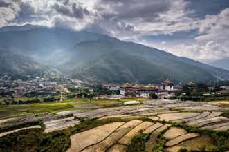
At the end of the road from Paro lies the Drugyel Dzong with Mt. Jhomolhari (23,995ft/7315m) behind – a beautiful point to start this trek. You will meet our trekking staffs and pack of animals here. You will walk along a dirt road for 1 hr through a richly cultivated valley called “TSENTO”. Tsento is the first small settlement you will encounter. You will see big, magnificent, traditional Bhutanese farmhouses with red chillies dried on their roofs in the season, small shops and a Basic Health Unit which cares for the people who live far away from Hospital. You will cross a Swiss – built suspension bridge at the end of the road.
The trek continues on the east side of the river. After 2 – 2.5hrs, you will stop for lunch near a Chorten (Stupa) at 8,450ft/2,577m. After lunch you will cross the main bridge and continue on a pleasant trail leading towards the Hamlet of Chobiso where you will enter Jigme Dorji National Park. At Gunitsawa, the camp has big school and some shops, and your trekking permits will be checked at the entrance. You will continue walking through the camp and cross the bridge over Paro Chhu. After 20 minutes of climb and descend through the forest, you will reach Shana camp site (9480ft/2890m) by evening.
Time: 6 – 8 hrs
Distance: 13.6 miles/22km
With a lot of distance to cover, it is going to be a hard day. After lunch the trail will be rough and stony with many ascending and descending. You can count on a late arrival at camp. You will be following the river upstream on its right side on a muddy trail. After crossing the bridge, the trail climbs steadily through a beautiful thick forest of oak, rhododendron, bamboo and ferns. After 2 – 2.5hrs of trekking you will reach Shing Karap (10,170ft/3,100m). A clearing with two houses, Home-brewed beer is sold, and the house is plastered with empty bottles. Not far from here, the trail forks, you will turn right and trek towards Soe. After a short steep climb, you will cross a bridge and after five minutes, you will come across a big clearing in the forest,Thongo Samba, a possible lunch spot or campsite.
The trek to Soi Thangthanka continues for 3 – 4hrs through beautiful forest of birch, fir, larchmaple, blue pine and rhododendron. After trekking for three hrs, you will be crossing a bridge, Yaks may be encountered from here, and make sure you move onto upper side of the trek, not the lower, as they pass. A short climb follows and a second bridge appears ahead, at the confluence of two rivers. After crossing the bridge, you might see Jhomolhari on the way to a big valley called Soi Yakse. You will continue trekking for 20 – 30 minutes on a good trail to reach Soi Thangthanka.
Time: 4 – 6 hrs
Distance: 10.5 miles/17 km
After enjoying the view to Jomolhari and a good breakfast, you will be walking for 1 hr through forest. Today’s trail again follows the river and changes direction several times. Late in spring, you may spot Blue Poppy (Bhutan’s national flower). At Heansho Thangkha (12,235ft/ 3,730m), you will come across Bhutanese and Indian army camp which has a Helipad, and guards another pass into Tibet. About 1 hr beyond the camp, you will come across a beautiful campsite Geza, where the yaks are kept here in winter. Today you will come across small villages. You might be invited into one of the houses for a cup of the famous butter tea, and it is impolite to refuse. You will have lunch somewhere in one of the villages.
By now you will be able to see the summit of the spiky peak Jitchu Drakey (22,470ft/6,850m) and Tsheri Kang to the right (21,405ft/6,526m). When you see a ruin of a Dzong, located on the rock, decorated with Prayer flags, you are inching closer. After crossing a bridge and suddenly the overwhelming snow- and ice- covered east face of Jhomolhari (23,995ft/ 7,315m) appears with its massive 3200m-high wall of granite, marble, and quartzite. You have reached Jhomolhari camp. Jhomolhari camp is where mules and horses are changed for Yaks.
Most people will feel the effect of ascending 1800m in three days, so a rest day at Jhomolhari camp will help with acclimatization. There are some good day hikes from Jhomolhari camp, and it is important to hike today so that you will acclimatise. Follow the standard rule: trek high, sleep low.
Side trips for the day
1 An easy day hike up the valley towards the foot of Jhomolhari. You can take the trail that climbs the moraine and this walk gives a good view down to the glacier. Watch out for herd of Himalayan Blue sheep in this valley.
2 A beautiful hike that goes eastward up to the twin lakes Tso Phu (14,270ft/ 4,350m), which are full of Trout. From the lake there is a spectacular view back to Jhomolhari and Jitchu Drakey.
3 The most challenging day hike is up the steep, grassy ridge located next to camp to the north. It takes 3 – 4 hrs to reach the final rocky summit (15,974ft/ 4,870m). You can get the views of Jitchu Drakey and Jhomolhari peaks. You can get your windproof jacket, gloves and hat.
4 A very pleasant hike (2 – 2.5hrs up, 1 – 1.5hrs down) goes in the direction of Jitchu Drakey. Walk northeast from the camp, following the same trailnused to cross Nyile La to Lingshi. After crossing the last house, cross the bridge and turn left and follow a less steep trail into the valley that leads to the foot of Jitchu Drakey. A little bit higher up there is a big, flat meadow that used to have a memorial plaque for two Italians who were killed in Jitchu Drakey in 1984. This hike gives you a very good view of Jitchu Drakey, Jhomolhari and the glaciers.
5 Another viewing point is the steep, grassy hill (16,334ft/ 4,980m) that starts from the second bridge. It is about 3 hrs hike and you get a superb view back to Jhomolhari/ Jitchu Drakey groups and camp.
6 Try to climb up the rock on which the ruined Dzong is situated. Be prepared to climb grade V Difficult and higher.
Time: 5 – 6hrs
Distance: 13 miles/ 21 km
Walk north to the houses of Jangothang. After crossing the last house, you will come across a log bridge crossing the river. It is a long climb – 3 – 3.5hr- to reach the first high and very windy pass of this trek the Nyile La (16,040ft/ 4,890m). Today’s trek will test your level of acclimatisation. If you are having problems this is the time to turn back. From Nyile La you can gate a view of Tsheri Kang (21,405ft/ 6,526m) dominates towards the north and The Tiger Mountain (6,840m) towards the east. From the pass, descend a short, less than 30min down to a flat, and more sheltered area where you will have lunch.
You can continue your trek and passing a narrow George with a small river crossing, you can spot Masang Gang peak in the far distance. From here the trail will be easy, flat and good, leading to a viewing point from which Lingshi Dzong can be seen, a solitary structure in the middle of an enormous wilderness. The camp is located near a ruined tourist bungalow.
For rest of the day, you can explore Lingshi village if you wish to.
Time: 8-9hr
Distance: 13.6 miles/ 22km
By now you should be well acclimatised and ready to cross another beautiful pass. It is a hard day, so start early. Take the trail through the rhododendron forest towards east. Turn a corner and go south into valley with few trees. The climb rises steadily to an altitude of about 4,450m, after leaving the camp. After 1.5hr from here you will reach the big cairn on top of the Yale La (16,235ft/ 4,950m), with views towards snowy Mountains around Lingshi and the Basingthang peaks to the south. The trail is well marked as people travelling between Lingshi and Thimphu used the Yale La. You will walk from here following the river and crossing sandy slope towards Shodu (13,380ft/ 4,080m) campsite.
Time: 4 – 5hr
Distance: 8.7 miles/ 14 km
Pass a deserted military camp and follow the trail to the river through the limestone valley. Monks use the caves in the rocks; Zhabdrung is said to have meditated here. Cross the bridge over the main river, which offer good views of giant rock faces and waterfalls and at the end of today’s trek, the trail gradually ascends 130m to the Barshong Dzong ruins (12,200ft/3,720m). There is a campsite below the Dzong, but it is muddy, you can carry on for 1 – 1.5hr to a better campsite. Barshong village is very small, number less than half a dozen houses.
Time: 4hrs
Distance: 9.3 miles/ 15 km
Cross a small stream, “Tsongju Chhu” and make a steep descent on a rocky trail ending at the Wang Chhu. The trail has several ups and downs and crossing of smaller streams. The trail will lead you to a split point; the one to the right descends to the campsite for tonight, Dolamkencho (10,970ft/ 3,290m). But continue up to a cairn at 11,315ft/ 3,450m.
Climb back from the campsite up to the cairn at 11,315ft/ 3,450m, from where the route descends to a side stream (10,070ft/ 3,070m). There are small ups and downs and descend a vertical cliff before finally reaching the last stretch to Dodena. The trail descends through Bamboo forest, following the mule trail high above the river until it finally meets again at Dodena. A large sign marks one of the entry/exit points of the Jigme Dorji National Park, and a beautiful Bhutanese-style bridge marks the path to Cheri Gompa.
To foster meaningful connections with our country, Bhutan Instant Travel, with its dedicated staff, offers its clients various tours with specials such as safaris, hot springs and home stays amongst others.
If you are looking for an entirely unique travel beyond the regular tours that we provide, fret not, because we also offer customized itineraries to suit your interests.
From providing accurate information and prompt response to taking care of your desired comfort, we, with our experienced guides and drivers, commit to arrange memorable holidays for you so that you leave with every sense of satisfaction. Read More...

 4D/3N
4D/3N
 7D/6N
7D/6N
 8D/7N
8D/7N
 14D/13N
 6D/5N
6D/5N
 3D/2N
3D/2N
 10D/9N
 7D/6N
7D/6N
 14D/13N
 9D/8N
9D/8N
Birding Tour for Corbett and Uttarakhand
Corbett - Pangot - Kumaon - Sundargarh - UP East - Sahibabad
 9D/8N
9D/8N
 9D/8N
9D/8N
Honeymoon Tour To New Zealand - Colors O..
Auckland - Rotorua - Queenstown - Christchurch
 9D/8N
9D/8N
 9D/8N
9D/8N
 9D/8N
9D/8N
Ahmedabad - Bhuj - Kutch - Dwarka - Somnath - Rajkot - Sasangir
 9D/8N
9D/8N
 9D/8N
9D/8N
 9D/8N
9D/8N
New Delhi - Katra - Anantnag - Srinagar - Ganderbal - Baramulla
 5D/4N
5D/4N
 7D/6N
7D/6N
6 Nights/ 7 Days - Bhutan Happiness Tour
Punakha - Bumthang - Paro - Thimphu - Phobjik
 7D/6N
7D/6N
 7D/6N
7D/6N
 20D/19N
20 Days Land Package Country Tour Bhutan..
Punakha - Paro - Phuntsholing - Bagdogra - Bumthang - Mongar - Trashigang - Trongsa..
 4D/3N
4D/3N
 6D/5N
6D/5N
 7D/6N
7D/6N
 7D/6N
7D/6N
Rimso 7 Days 6 Nights Bountiful Tour fo..
Thimphu - Punakha - Paro - Phuentsholing