6 Nights / 7 Days
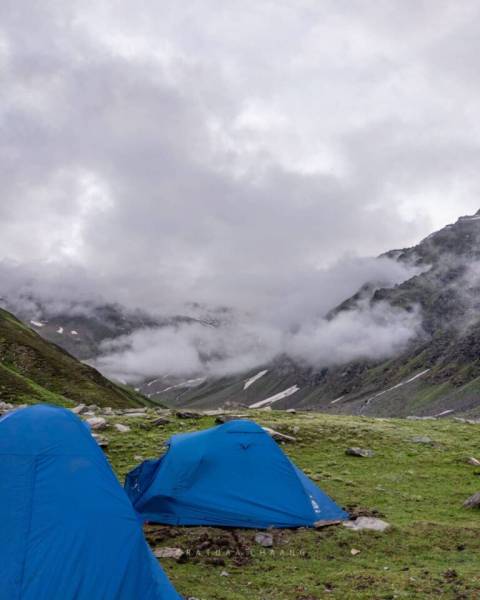
We always keep hearing about Pin Bhabha pass as a comparison to Pin Parvati pass trek. In reality, they are extremely different treks. Though they have only Pin valley in common. Pin Bhabha pass is the confluence of Pin and Bhabha valleys. That also means it is the perfect mixture of Himalayan greenery and it’s aridness.The Bhabha side of the trek is a cruise to livelihood. It is filled with dense alpine forests of Pine, Oak, and Silver Birch. The beginning of the trek is itself through long dense trees alongside the Bhabha River. Very rarely is there long trudging through pine forests. Slowly as you gain height huge grasslands flourished with vibrant blossoms come into the picture. Most of the campsites are on pastures with the Bhabha river and lakes beside the tents. Kara grasslands are the most popular amongst Shepherd.Goats, horses, etccan be seen in abundance here.The more you rise above, gradually the vegetation is lost to scree, snow, and moraines. The path to the Pin Bhabha pass will test endurance just like any other pass trek. But the moment pass is reached it is a complete contradiction to the sights seen until now. Suddenly the brown, yellow, red mountains pop up while entering Pin valley. This marks the start of Spiti. This turning of scenery is awesome and remains in the memories forever.
The trek starts from Kafnu, which is a charming hamlet in the Kinnaur.
In the morning so we can start our long drive up to Kafnu – a charming hamlet in the Kinnaur district of Himachal Pradesh. Although there’s nothing more on the agenda for today other than the 10-hour drive, it is better to leave as early as possible for two reasons:
One, so we can reach as early as possible and give our bodies enough rest for what’s coming the next day. And, two, roads on the mountains are unpredictable and it is always better to account for delays when we start. It is also better to reach before it gets dark. The drive to Kafnu takes you on scenic mountain roads.
The roads run narrow in many parts with a deep gorge on the other side leaving the area prone to rock fall and landslides; do not expect this to be a smooth ride. In some areas, the roads look like they are straight out of Need for Speed – smooth but narrow, under hanging boulders on top of a high mountain with a drop on the other side. A few patches in the last 20 kms of the drive are not concrete; these sections take a lot of time to navigate. After crossing the Wangtoo, bridge, which is the last 1 hour of the drive, the expansive views of Kinnaur Ranges make themselves available for your viewing. At the end of the trail of this back-breaking journey will be a warm, wooden homestay with cozy rooms, waiting for you. Expect to reach latest by 7 PM.
After a small round of introductions, briefing about the trek and what to expect on it, everyone has dinner, settles into their rooms and calls it a day.
After a comforting stay for the night, in the midst of apple orchards right by the gurgling river, we start our trek at 9 AM to the morning sound of Himalayan birds. For the first three hours, we walk on a motorable road in the vicinity of the Janglik Range while a turquoise Bhaba river cascades alongside us, in the opposite direction. With its sharp turns and high falls, the river is a constant source of energy all through the trek today. It consistently cheers you on with its roaring sound.
Just 15 minutes into the trek, we start seeing thick layers of old snow forming snouts for the river.
Be prepared for multiple river crossings on bridges made by unsupported logs placed next to each other. If you have a fear of water, things could already start to get interesting for you. Within two hours of the trek, we would have already covered 400 M of the climb with just 500 M more to go. By 12 in the noon, we enter the door of the forest. Halfway through the day, we would be walking in the woods. Half an hour into our walk, we station ourselves under the shade of the sky-high trees to have the packed lunch we were given at the beginning of the day. Post lunch, we continue on into the forest, navigating big boulders and mushy land. After an hour, we will encounter a patch of sharp descent where we lose a little height and by around 2:30 PM, we would have reached vast open meadows with the tallest ferns you have ever seen. It feels good to be under the sun once again after having walked through a forest with a closed canopy. The first campsite is not far from here. As you keep walking straight into the meadows and the land opens up around you even more, you can already see the tents far into the distance. The Bhaba river distributes itself in little streams all through the floor of the lush green meadows.
Expect to make it to the campsite by 3 PM. Mulling is a beautiful, bovine rich campsite with horses and trees all around your tents. Scattered colors paint the ground in the form of wild flowers and the river flows by your feet. It would serve you well to soak in the view since this campsite marks the end of the tree line for the trail.
After some stretching and briefing, you will be served hot soup/tea and then you are free to explore this magnificent landscape till dinner time at 07:30 PM. It is important to get some rest after dinner since this is your first night in a tent and at a higher altitude. Give your body some time to adapt to the change in external conditions so it is better able to carry you through to the last day.
Today is comparatively easy because the distance is almost half of yesterday.
There are two major challenges we will be encountering on the way. One is crossing over the forceful river which requires team work, a little technique and soaking your feet in the gushing flow of the icy cold water. The next is a 300 M sharp ascent which is a little tiring, especially because of the weight on our backs.
Post a rejuvenating yoga session and a warm breakfast, we begin the trek at 10 AM. Today’s route has us follow the river upstream through vast open meadows. There is a clear trail which leads you to the next campsite.
The first half hour is a straight walk in the meadows which leads to a slight climb to get into the forest area. After 15 mins of ascent, you are literally ‘in the woods’ – suddenly everything is darker and chillier till you cross the forested area across the stream and onto the other side of the mountain. The climb today involves navigating a lot of huge boulders. Other than some tricky sections, these boulders actually aid the hike, proving to be like a climb up the stairs. While you struggle to continuously shift your weight on the big rocks, do not forget to look up and watch out for the magnificent cloud shadows on the barren dips in the mountain faces creating a beautiful play of dark and light shades of green. The wild flowers in the meadows here are a deep yellow and the fairest shade of purple scattered across the valley like spilt beans. We spend the next few hours through the mountain across meadows on a gradual uphill climb and reach the campsite by 02:30 PM. The last bit of the hike today involves dipping your feet once again in glacial water in order to reach the warm sanctuary of our tents.
As soon as you are done stretching, you will find hot lunch waiting for you in your dining tents! You can enjoy your lunch with the snowclad mountains much closer to you than before. Save your plates from the sheep grazing across the meadows at your campsite – they might be in the mood for something spicy!
Today’s trek is shorter yet but is a much steeper incline. We follow the same routine as Day 3. Get up, do some yoga/ work out, tea, breakfast, pack up and leave by 10 AM. It is a hard day for the legs – firstly because of the steep ascent and secondly because the trek starts with multiple river crossings. We have to cross the streams crisscrossing through the meadows. Because the force of the water is high, this will require rolling up your pants and getting to work as a team in order to successfully make it to the other side. There are around 6 streams to cross to make it to the dry land on the other side – that is thirty straight minutes of bone-chilling water adventure.
All this as the green, rocky mountains look at us struggle to keep our feet dry. The cloudless sky makes the tall mountains look almost 2 dimensional against the solid blue of the clear skies.
Once out of the freezing water, we start to notice other colors and forms getting added to the landscape around us. The color palette of the meadows here is much richer than it was yesterday.
After sections of glacial walking, which require extreme caution and balance, we hit another slice of steep incline for the next 40 minutes. There is also a small water source here after which we hit a precarious section of the trek- a narrow trail which rests on loose rocks with a drop into the valley on the other side. This section needs to be crossed very carefully. It is important to move continuously on sections like these because standing in one place could result in loose rocks slipping down taking you with them.
Beyond this point, you enter the land of meadows lying alongside glaciers. It is a sight to behold not just for the frenzy of colors but for the marvel of the coexistence of extreme cold and life in the form of summer flowers. There are a lot of small sections of glacier crossing today. After a slight climb, we reach the campsite called Lower Pushtirang. When there is excess snow, this is where we camp. In case the snow has receded, we continue on for 20 more minutes to reach Upper Pushtirang. Expect to reach here by 02:30 PM.
After stretching, we get ready for tea and then the disbursement of equipment. For our next day, we will need microspikes and gaiters to be able to cross the snow-loaded pass. Expect knee deep snow while crossing the pass. After each of us checks the equipment and learns how to use it, we have an early dinner by 06:30 PM.
We tuck in soon afterwards to get some rest as the next day begins at 3 AM.
Today is THE day! Midnight climb, steep incline, walking in knee deep snow, micro spikes, pass crossing and a crossover into the other dimension!
Day 5 starts a little after midnight. Wake up at 2 AM, pack our bags, put all our gear on, have some light breakfast, pick up our bag and off we go, by 03:00 AM! The night is really cold here, remember to layer up accordingly.
Before we begin, the trek leaders will allot a specific sequence for the trekkers. The slowest person of the group remains in front and everyone else is lined up accordingly. This is to ensure we stay together as a group so as to battle the perils of a night climb together. Remember to bring your head torch for the trek.
There are no water sources for the next 6-7 hours; so do remember to fill all your water bottles before you leave camp.
The climb is interesting from the get-go. From the minute we put one foot behind the other, we find ourselves navigating big boulders on a steep incline – The climb up is likely to take anywhere between 5-6 hours. Expect to reach the pass by 9 AM. The 6 hours of ascent is riddled with precarious sections teeming with rock fall, glacier crossing, scree, moraine and navigating big boulders – all in the dark of the night.
At 5, as the birds come alive, remember to look up and witness the pastel glow of the sky at the crack of dawn. The soft hues slowly get deeper as the snow-clad mountain tops become a resting place for the rising sun. The crack of dawn presents a panoramic view of the Kinnaur, the Spiti and the Janglik Ranges with snow patches rolling down mountain faces like sweat.
The climb now gets steeper and more difficult. Once the rock and scree area end, we are presented with an endless sheet of white snow. Here is when we put our microspikes and gaiters on to start our traverse on snow.
The view from the pass, which is the highest point of the trek at 4,915 M, is nothing short of spectacular. The prayer flags, the panoramic view with the assault of greens on the one side and browns on the other, while you find yourself in knee deep white (snow), is an experience like no other. It is your passage between two distinct worlds – that from the abundant and alive Bhaba valley in Kinnaur to the dry, resilient and almost galactic Pin Valley in Spiti.
We spend thirty minutes at the pass and then start our descent. You start to appreciate the ascend when you hit the slopes to go down. The snow now starts to get slushy and hence a little more difficult to walk on. If you are lucky and there is enough hard snow, we will be able to cover a lot of distance by sliding down the icy slopes.
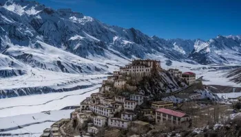
The change is terrain is so stark, it’s mindboggling. We have now entered the Pin Valley on the Spiti side of Himachal. You are invited to the barren landscape with hundreds of shades of browns and dirty red. The Pin River now adorns this landscape flowing calmly through sun tanned rocks. It is a long trail; expect a lot of rocks and dust for the lack of vegetation.
You will meet the end of snow by the time we arrive for lunch – by 01: 30 PM. The trail now takes you alongside the blue Pin River. The trail is pretty straightforward. There are some sections which are tricky though, with very narrow trails, deep gorges and loose mountains. Slipping on these slopes will take you straight down into the strong flow of the river. Although, called the cold desert, it is not devoid of color and you learn to see beauty in elements other than the flora of the mountains. From the lip of the valley you look down on the confluence of three rivers at Tiyaand, a trail junction. The land is rich in medicinal plants, and colorful shrubs spilling out of the barren land – a strong, pleasant smell from these assortment of exotic plants follows you all throughout. You will meet patches of snow all through till you reach the campsite.
It has been a long day. Stretch yourself and lounge in the sun to cool your body off for a bit. After we serve our stomachs, we hit the bed early because we need to cover a long distance the next day as well.
Today we head on from Baldar to Mudh Village through Pharka Village. The walk is long but is fairly straight; not very stressful. With no rush, we leave after a hot breakfast at 10 AM. We will get packed lunch today.
The walk today does not involve too many ups and downs but it does have a few river crossings over log bridges without ropes – but we are sure after all these days, you’d have conquered your fear of water, if any. Within 40 minutes of the trek, we start to see our destination for the day – Mudh Village – far into the distance. There are small patches of steep, narrow, muddy trails which need to be crossed cautiously.
With the colors of the earth, spilling out of its dry cracks in the form of tufts and a strong smell of the herbs following you on the trail like a stalker, we stop for lunch near water. Our destination is not too far from here.
There are two major obstacles between you and the village:
A 30 M long swinging bridge over the Spiti river. This almost unwarranted bridge, dangling between two mountains with nothing but two strings to support it, will bring back all the dizziness of the last 5 days.A 20 minute, extremely steep climb to get to this tiny mountain habitation rife with cafes and homestays.Expect to reach the village by 03:30 PM. After you explore the peculiar mountain culture and are done introducing your taste buds to their local Himalayan cuisine, we hit the road again, this time to drive two hours to the town of Kaza. This is where we end our trail for the trek. Expect to reach Kaza late evening. Do remember to book your accommodation in this town before you lose network at the beginning of the trek.
Kaza is the largest township and a commercial hub of the Spiti valley. Famous for its monasteries and local shopping, there are a lot of small hamlets close to Kaza, for you to explore. A window into how people co-exist with the exotic wildlife of the terrain, their peculiar houses, lifestyle and means of livelihood in this barren land are every bit as fascinating as the trail for the trek.
To head out of Kaza, you can either hire private cabs or look into local buses. It is a good idea to arrange for your transport out of the town one day in advance.
Pahadiyatra is a well-known tour and travel, service provider. We are mainly busy making your travelling journey relaxed. The essential aim of our organization is to create all your travelling experiences stress-free however this can be possible starting from booking the tickets and vehicles. We have effectively delivered our services to our flat customers at a very exact price in Himachal Pradesh and other parts of the country.
Our some ranges of services surrounding all the booking services start from tickets to hotels as well. Armed with many lively facilities in these elements which are made based on calm lifestyles & luxury.
Our establishment
Since our start in 2021, we have been flourishing all-embracing consultancy and link services in a dependable and advanced manner. We facilitate services from the state of Lucknow, Himachal Pradesh forging an exciting deal of planned connection with the government agencies. Our services request capable business deals and foster pleasant relatives among corporate, foundations, voluntary organizations and the government.
Our services
As a visible and trustworthy name in this business domain, we are efficiently leaving the role of Tour Operators, Passport & Visa Services, Hotel Booking, Car & Coach Rental, Railway Ticket Booking, Hotel Booking, Travel Insurance Services and Flight Booking.
Why us?
Prepared with huge knowledge and experienced staff
Set-top visions of skill for yourself and your expectation.
To design the travel necessities as per your obligation
Measurements working with exceptionally skilled and trained staff
Careful to keep your details always stay confidential with us
Equipped with a satisfactory amount of staff to serve your Read More...
 6D/5N
6D/5N
 6D/5N
6D/5N
 4D/3N
4D/3N
 5D/4N
5D/4N
 5D/4N
5D/4N
Kashmir Honeymoon Special 4 Night and 5 ..
Srinagar - Pahalgam - Sonamarg - Gulmarg
 4D/3N
4D/3N
 5D/4N
5D/4N
 3D/2N
3D/2N
 5D/4N
5D/4N
 7D/6N
7D/6N
Shimla - Manali – Chandigarh Tour
New Delhi - Shimla - Manali - Chandigarh City
 7D/6N
7D/6N
 7D/6N
7D/6N
 7D/6N
7D/6N
Amritsar Chandigarh Delhi Agra Family Pa..
New Delhi - Agra - Vrindavan - Mathura - Amritsar
 7D/6N
7D/6N
 7D/6N
7D/6N
 7D/6N
7D/6N
Golden Triangle - East India Tour
Kolkata - Puri - Imphal - Agartala - Dimapur
 7D/6N
7D/6N
 7D/6N
7D/6N
 11D/10N
10N - 11D Spiti Avneter Manali Tour Pack..
Kullu - Manali - Naggar - Sarahan - Shimla - Sangla - Chitkul - Tabo - Kalpa - Kaza
 8D/7N
8D/7N
7 Nights - 8 Days In Kinnaur And Spiti V..
Manali - Shimla - Lahaul & Spiti - Tabo - Kalpa - Kaza
 11D/10N
Kaza Narkanda Sarahan Kalpa Serchu Keylo..
Kaza - Jispa - Kalpa - Narkanda - Chitkul - Lahaul & Spiti - Kinnaur
 8D/7N
8D/7N
7 Nights 8 Days In Kinnaur And Spiti Val..
Manali - Shimla - Lahaul & Spiti - Tabo - Kalpa - Kaza
 7D/6N
7D/6N
Exclusive Winter Spiti Package
Shimla - Kinnaur - Lahaul & Spiti - Chitkul - Kalpa - Kaza
 4D/3N
4D/3N
Sarahan - Shimla - Lahaul & Spiti - Sangla - Chitkul - Kalpa
 19D/18N
Tribal Tour For Kinnaur - Spiti 18Nights..
Sarahan - Shimla - Lahaul & Spiti - Sangla - Chitkul - Kaza - Kinnaur
 10D/9N
Kinnaur - Kaza - Spiti Romantic Package
Chandigarh City - Shimla - Kinnaur - Kaza - Digboi
 8D/7N
8D/7N