7 Nights / 8 Days
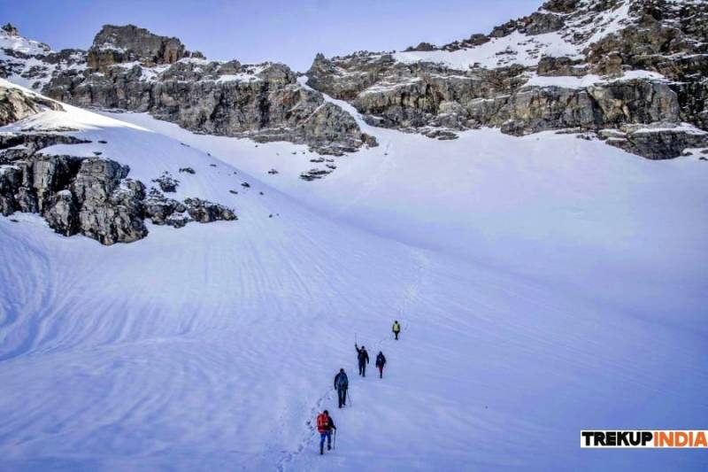
Surprises await you at every turn and are sure to fulfill every wish your adrenaline-pumping heart desires. The essence of the trek lies in its achievement. There is something to be said for the overwhelming sense of accomplishment one gets when standing at the top of the Rupin Pass and admiring the view that took you almost a week to get there.
We kid you not, this trek is not for beginners, it is more of a milestone to reach after you have covered most of the treks in India. It is admired by many world tourists because it has the most amazing views combined into one amazing journey.
The difficulty of the Rupin Pass Trek is certified as moderate to difficult, so it will test you in terms of how much effort you can put in, making the most of your trekking gear and also how well you can handle trekking for more than a week. You will need equipment such as trekking poles, gaiters and multiple layers of clothing, among other things. The trekking distance of Rupin Pass increases up to 15 km every day, which you should cover in 5-6 hours.
Many say the terrain is rough and the trails undefined – the steep climb around Rupin's three-stage water wall will require a lot of endurance and lung power, but the scenery of the trek is what draws the crowds to come to conquer it. this summit. The ever-changing scenery from snow-capped mountains to meadows, waterfalls, pine forests and lakes is what makes the Rupin Pass so enchanting and at the same time quietly exhausting. That is why it is easy to call Rupin Pass Winter Trek a complete package trek
You can see two sides from the pass. On the edge of the mountains lining the valley and on the other side there is a full view of the Dhauladar range that you have left behind. The rocks forming the lining of the Rupin ski Pass branch out from the edge. If you move to the Sangla side, you will notice that the descent is a steep way down and trying to walk below will be unlikely. So scrolling down is the only option that can be used. Follow our expert guide to slide down the Rupin page fast. The slide is on a white blanket of snow, which makes it very memorable. It has three stages, and once you hit the first one, you can never get enough of sliding.
This camp is called Ronti Gad and it is breathtaking. It won't take you long to notice the difference between this grassy knoll and the others. Here is a view of the snow-capped mountains high above you. The view is green and white and gradually greener as your scene moves south. It is very important that you stay warm this night as it will be our coldest night camping. Enjoy the Rupin pass trek with Onmap.
Drive Duration: 9-10 hours, Drive Distance: 226 km
Altitude: 5150 ft
Highlight:
The base location for Rupin Pass trekking is Dhaula.
It is a small, laid-back village with a few houses located in the side streets of Uttarakhand. Getting to Dhaula is an experience in itself as you drive through the beautiful mountain roads.
9 to 10 hours drive surrounded by dense forests and valleys starts from Dehradun railway station which we organize at nominal cost.
Trek distance: 6 km, Trek Duration: 5 hours
Altitude: 6300 ft
Highlight:
A day after reaching Dhaula we head to SewaGaon. We take a village track to get out of civilization as we pass a cattle shed and manure storage to get up a sharp incline. After completing this ascent, which takes about 15 minutes, you will encounter your first change of environment. Your view of the village will now change to Rupin on the river bed below.
A heartwarming view awaits you of several villages around the valley dotted with children hopping around. Carry enough water, at least 2 liters, from the campsite or top up from natural sources along the way. The restaurant is located on top of a cliff with the Rupin happily flowing beneath it and will be your last source of food before we reach Sewa. SewaGaon will be the camp for the day and is 6330 ft above sea level. The village temple boasts a rich culture and is well worth a visit.
The curve of the trail takes us to another change of scenery – Rupin racing through the valley, while a high cliff rises majestically above the river; his head covered with clouds and his face made of solid rock. Our trail will now continue through the apple trees and about 30 minutes down the trail you will come across a small pub run by a kind young girl.
Trek distance: 8 km, Trek Duration: 7 hours
Altitude: 7720 ft
Highlight:
This day we move out of Sewa, you’ll suddenly dip into the forest. This forest is very dark as it is covered in large, dense trees that don't let much light in. and now you'll realize you've been getting closer to the river at this stage. Once the forest is cleared, we will be trekking up the river rather than along it, which means you will have to jump and jump over the many streams that make up the Rupin. Carry a sufficient amount of water from the campsite, at least 2 liters, or refill it from natural sources on the way.
As soon as we turn left onto the path, you will come across a wooden bridge over a stream. This is quite a strange sight as there are Uttarakhand and Himachal Pradesh on either side of the bridge.
Be prepared for a challenging set of climbs that are balanced by sections of flat walking after each climb on this day. We will then continue on any of the trails to the left of the roads to meet the trail to Jiskun.
The next part of the trail is mesmerizing with the thrill of the climb. First, the trail narrowed quite a bit compared to what we were walking. You will be walking along the precipice at its edge and when you look down you will see Rupin below you shining like a million diamonds.
crossing the stream and a long climb up the hill. After that, we will have to climb for 30 minutes to reach upper Jiskun and you will see the first post office of Himachal Pradesh. If you're running low, you should stock up in Jiskun.
Trek distance: 8 km, Trek Duration: 7 hours
Altitude: 10150 ft
Highlight:
On this day 3km walk to Jakha is mesmerizing, the trail from Jiskun quickly descends into dense deodar and walnut forests until you reach the dark fold of the mountain. We will then climb to Jakha for an hour and as the trail keeps changing, so do the scenic views you will encounter.
Jakha is the last village on the Rupin Pass trek, so it will be very important to stock up on supplies. The trail continues across the field and passes the upper Jakha fields.
We then enter a fir forest where you will find a few maples among the pines and the first patches of snow can be seen as you climb this trail. A vast snow bridge spread over the Rupin, which stretches below.
Wear your sunglasses, you can walk across the snow bridge and feel the snow under your feet for the first time on this trek. Get to know the feeling because where we're going there's going to be a lot of snow! We then take the trail over the snow bridge and continue our trek toward Rupin Pass.
After about an hour of walking on boulders and jumping over tributaries, the trail gradually leads into the forest. The forest has a clear and green clearing once the trail turns right and is marked by a larger stream that gushes fresh water down the hillside. It is called Burans Kandi and this will be the camp for the night.
Trek distance: 6 km, Trek Duration: 5 hours
Altitude: 11720 ft
Highlight:
Once we get back on the trail back into the forest, the scenery changes again as we enter a cluster of bushes. The ascent here is quite challenging due to the steepness. Flowers of various colors bloom here and soon you will be surrounded by shrubs and dwarf rhododendrons. A few flowers even touch the water, giving a very unique visual effect.
The trail continues through the bush and then moves to a small clearing with rhododendron flowers covering the slopes and the plants here grow quite tall. Going further, into a larger gap, you will be greeted by another visual experience – an island that is lush with green pastures and silver birch trees, dividing the river in two, and in the distance, the Rupin waterfall flows in slow motion. will be seen. This scenery is nothing short of captivating!
We will then descend from the yellow flower fields and enjoy a slow walk towards the first obstacle of Rupin Pass Trekking which is the snow bridge on the river. The snow bridge requires careful tread as it is steeper than it looks, so solid footing is recommended. However, the steepness does not last very long and can be quite exciting. Once we cross the snow bridge, you will be on the bank of Rupin.
The trek turns into a smooth climb, surrounded by plush meadows. We have to cross the river by jumping over boulders and over wildflowers of blue, green, yellow, white and purple, while the icy blue Rupin gushes down the valley. We will also have to cross a boulder at the edge of the river as the valley rises above the wide river bed. We reach the river bed and cross the valley over the largest snow bridge on the Rupin Pass Trek.
We climb over Rupin once more to reach the foot of the plateau. The climb is steep, slow and strenuous to say the least, but the view that awaits your arrival will be more than just makeup. All the climbing will be put out of your mind when you look at one of the most beautiful meadows in this part of the country and we camp here, from where you can admire the view of the famous three Rupin waterfalls. You will reach the center of a large valley basin that is lined with snow-covered valleys and a little further on you will be able to see the Dhauladar range overlooking the range. At last camp here.
Trek distance: 4 km, Trek Duration: 3 hours
Altitude: 13110 ft
Highlight:
We will be climbing to a higher altitude and we will be climbing fast, just like the situation in the Himalayas. As a result, there will also be rapid oxygen depletion and many will be AMS compliant, which is why we split the climb over two days. The first day we will focus on getting to the top of the waterfall and allowing your body to adjust to the climate. On the second day, we will climb the Rupin Pass from the top of the falls.
The walk is very pleasant as you will be crossing and jumping over rocks, streams and boulders. Once we reach the snow patch that marks the start of the climb, we will follow the side of the path that will move through the snow patch instead of going straight through it. The waterfalls will be just next to us all the time. As we mentioned before, a trekking pole is your best friend when trekking in the Rupin Pass (apart from our trek leader, of course). An ice ax can be useful here, but even a trekking pole will be enough support.
We will have to start following the steps on the snow surface and slowly climb up the barely visible trail. The end of this climb takes us to the top of the falls where the vast landscape surrounds us. This is also a surprise as the Rupin Pass trail has a wide meadow extending to a flat bowl. Streams from these meadows flow towards the valley and form a body of water that flows into the Rupin. Once we get off the nose, you can sit on the edge and let your feet float freely. Finally, the top of the falls, which could only be seen by looking into the distance, arrived!
Trek distance: 14 km, Trek Duration: 9 hours
Altitude: 15390 ft / 13150 ft
Highlight:
We will start the trek with an hour section towards RatiPheri. The slope is steep, but the view will be pleasant if we take into account the beautiful meadows that will be around us between patches of white snow. The climb turns left after a while and brings us to a ridge that reveals the campsite. We will stop here briefly to catch our breath and replenish our water supply.
The valley stretches from where we climbed in all its glory. The Dhauladar range can be seen in the distance and behind it is the road we have been walking for the last six days and before you will lie thick layers of white snow. Sunglasses and gaiters will be a must from now on.
Now we'll start by walking through the snow, make sure your feet are steady with each step as the snow takes a while to get used to. Keep calm, you will slide and slide, so just laugh it off and carry on. You may even lose your footing and go knee-deep in snow, but don't panic, this snow floor only lasts until Rupin Pass.
Getting to the gorge is a short climb of 200 meters, which may sound easy, but the steepness of the trek and the loose rocks and boulders on the way up make it a climb that requires more than a few tricks. sleep. It's hard to get hold of on the ground as layers of snow descend. Sometimes we'll have to hold onto it with all fours and a trekking pole. If you have an ice axe, the whole activity is a little easier.
Just turn your neck to see Rupin Pass. It will be another twenty minutes before we reach the top. You will be able to see the Dhauladhar range that we left behind and further the Sangla range from the top of the Rupina pass.
Trek distance: 7 km, Trek Duration: 4 hours
Altitude: 13150 ft
Highlight:
On this day we’ll descend to Sangla is hell on the knees and feet, but it makes up for it with the ever-changing scenery. We leave Ronti Gad and descend towards Sangla, painfully aware that the steep walk down into the valley. However, the trail will make up for your suffering with the scenery of the Kinner Kailash range and the pine forests of the Baspa Valley.
As we lose altitude it becomes easier to breathe and it shouldn't take long to get relatively warm once you get close to Sangla. All lead to Sangla Kanda. Avoid only the trails that lead down to the river. Note the snow-covered Nalgani Pass on your right, which you can take another time. Meadows cover the entire stretch of mountains and hide the snow that covers them on the other side of the mountains. But the sight of the Kinner Kailash ranks is what wins the award from Rukti Gad.
As you will now notice the first signs of civilization mark by Sangla Kanda Lake and a small village. It will still take you about an hour of careful descent with bent knees to the village. We will stop in a village to rest and chat with warm and friendly people who can share a cup of tea with you over the stories of your conquest of the Rupin sky Pass together.
The path is now overgrown with pine trees, which will be the last surprise the trek has to offer. It is a nice and gentle walk along Rukti Gad towards Sangla which remains below you. The trail is quite wide and allows you to walk in groups compared to the previous day's trek. Sangla is not very far now. Once you cross the murky waters of the Baspa, Once you descend for a few minutes, you will reach the motorable road to Sangla. You can use many lanes to get you to the bus stop which also forms the center of the city, not unlike most cities in India. You can eat in restaurants at the bus stop or even use one of the cottages for a necessary bath and sleep.
Please note that you will have to take a bus to Shimla, the last one leaves at 5 PM and reaches Shimla early in the morning at 3 AM.
With the intention to exceed the adventurous expectations of tourists or travelers all around the globe, OnMap Adventure Sports Pvt Ltd starts operating the most pleasant adventure holidays in Uttarakhand for adventure lovers. From thrilling adventures to a family holiday trip, we are committed to offering you the best.
The safety of our customers is our prime concern and responsibility, so we every single aspect while arranging adventure tours for them. We let our customers enjoy the adventures at budget-friendly prices.
Apart from dealing in adventure tour packages, we are also engaged in providing packages for pilgrimage/religious tours, wildlife tours, and yoga & Ayurveda tours in Uttarakhand. Our detailed knowledge of the tourism sector enables us to present the beautiful land of Uttarakhand in a convenient and unique manner. We offer more choices that will surpass the customer’s expectations. We are also engaged in providing services for event management in New Delhi.
We are backed by a skilled and experienced professional team that is involved in providing a comprehensive package of adventure sports. With their support, we ensure the highest standards of quality which enhanced our credibility in the market.
Our energetic and enthusiastic team can help you through the whole process, from the inquiry phase, making necessary arrangements for adventure trips, and organizing the dream vacation to the end of your excursion. The team has got the industry knowledge & expertise and follows the best practices to ensure everything runs smoothly.
Read More...
 6D/5N
6D/5N
 7D/6N
7D/6N
 6D/5N
6D/5N
 2D/1N
2D/1N
 5D/4N
5D/4N
 5D/4N
5D/4N
 6D/5N
6D/5N
 5D/4N
5D/4N
 6D/5N
6D/5N
 8D/7N
8D/7N
 8D/7N
8D/7N
 8D/7N
8D/7N
 8D/7N
8D/7N
 8D/7N
8D/7N
 8D/7N
8D/7N
 8D/7N
8D/7N
 8D/7N
8D/7N
Delhi Shimla Manali Honymoon Package
New Delhi - Shimla - Manali - Chandigarh City
 8D/7N
8D/7N
 4D/3N
4D/3N
Sarahan - Shimla - Lahaul & Spiti - Sangla - Chitkul - Kalpa
 19D/18N
Tribal Tour For Kinnaur - Spiti 18Nights..
Sarahan - Shimla - Lahaul & Spiti - Sangla - Chitkul - Kaza - Kinnaur
 10D/9N
9 Nights & 10 days Shimla Kinnaur Spiti ..
Sangla - Kalpa - Tabo - Kaza - Manali - Shimla - Chitkul - Sarahan - Kinnaur - Giu ..
 14D/13N
Sarahan - Sangla - Kalpa - Tabo - Kaza - Lahaul & Spiti - Shimla - Manali - NAKO
 8D/7N
8D/7N
Spiti Valley - 8 Day - Fixed Departure T..
Lahaul & Spiti - Sangla - Chitkul - Kalpa - Kaza
 11D/10N
6 Valleys Expedition Himachal Tour
Lahaul & Spiti - Kinnaur - Kullu - Sangla - Manali - Kaza - Tabo - Chitkul - Kalpa ..
 9D/8N
9D/8N
8 Nights/9 Days Delhi to Shimla – Kalp..
Shimla - Kalpa - Tabo - Kaza - Sangla - Kinnaur
 8D/7N
8D/7N
Manali - Kinnaur - Lahaul & Spiti - Sangla - Kalpa - Kaza
 13D/12N
12 Night / 13 Days Haven Himachal Family..
Shimla - Sangla - Kalpa - Kinnaur - Manali - Dharamshala - Dalhousie - Amritsar